Washington Relief Map
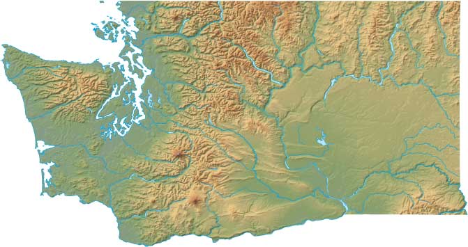
Static Washington Relief Map
Interactive Washington Relief Maps
The interactive relief map choices include a standard Google terrain map and an enhanced Google terrain map with Street View capabilities. To zoom in or out on either of these Washington maps, click or touch its plus (+) button or its minus (-) button, respectively. To pan either map in any direction, simply swipe it or drag it in that direction. To display either of these Washington terrain maps, click or touch one of the following menu options.
Washington's highest mountain is Mount Ranier, whose peak is 14,410 feet above sea level. The largest lake in Washington is Moses Lake. If you are planning a visit to Washington, please see Experience Washington, the official state tourism site, where you can find a wide range of travel and vacation information. For information about Washington history and recreational activities, visit the following National Park sites.
Washington National Parks
- Ebey's Landing National Historical Reserve
- Fort Vancouver National Historic Site
- Klondike Gold Rush-Seattle National Historical Park
- Lake Chelan National Recreation Area
- Lake Roosevelt National Recreation Area
- Lewis & Clark National Historic Trail
- Mount Rainier National Park
- Nez Perce National Historical Park
- North Cascades National Park
- Olympic National Park
- Ross Lake National Recreation Area
- San Juan Island National Historical Park
- Whitman Mission National Historic Site
Copyright © 2005-2024 State-Maps.org. All rights reserved.
Washington-Map.org is a State Maps reference source.
To facilitate browsing, certain external links will open in new windows.
Washington-Map.org is a State Maps reference source.
To facilitate browsing, certain external links will open in new windows.